介绍:
20160623ou 一中两外锵锵三人行
今日话题: 地图上为什么一定是上北下南呢?
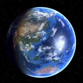
Lincoln: Now, Yoyo, if I had to say to you, if you looked at the earth from space, which part would you say is the top?
Yoyo: Of course the north pole.
Lincoln: The north pole. Michael, what about you? Pretty much similar?
Michael: Yeah, yeah. North is at the top, isn’t it?
Lincoln: But actually, have you guys ever wondered why north is at the top? Why, when we look at a picture of the world, why do we actually think that north is actually at the top?
Yoyo: It’s on most of the maps.
Lincoln: But why? Who was the first person to decide that that was how it was supposed to be? So this is a really interesting article that I came across. It basically has got to do with the idea that maybe, you know, the way we view the world, the maps that we see, maybe they aren’t necessarily the way that the world is, Michael.
Michael: Well, I mean, if you’re looking for a point to put at the top or the bottom, it seems natural that you’d put… I mean, obviously, you’ve got the north and the south pole at each extremity of the earth. It seems natural that one of those goes at the top and one of those goes at the bottom, but I suppose, taken in isolation, there’s no reason to suggest that north should be at the top, because, you know, the world’s round, isn’t it? You can’t, strictly speaking, have anything at the top.
Lincoln: Yeah. At the same time, being able to orientate yourself and navigate, that’s an important human skill. The first map actually came down from 14,000 years ago, which was scrawled on a [wall] in the Abauntz Cave in Navarra, Spain, and the idea is that when you were out in the savannah, or out in the fields, being able to know your way back home was your survival, because there’s no light – if you’re in the field, you’re in the field and lost, so you need to know where you’re going, or at the very least, know where you’re not trying to go, so the kind of inclination and desire to draw a map has been really important. Like, for example, Wu You, here in China, one of the strangest things I recall is that China is in the middle of the map, as opposed to Africa and Europe, which is in the West.
Yoyo: Yeah, that was the common situation when I saw most maps, and especially in the geography textbooks. There was always a joke talking about the fact that we are the Middle Kingdom, and the centre of the world. I believed it because I had proof, because on most maps we are in the middle.
Michael: And the funny thing is, when I first came to China and I saw all these maps with China in the middle, I thought that was really strange, because I’m used to seeing maps with Europe and Africa in the middle, and you talk about China being the Middle Kingdom, Wu You; we talk about China being in the Far East, so it’s just your perception of where it is, and what’s really strange to me is, obviously you’ve got China in the middle, and then you’ve got the entire Pacific Ocean, the whole thing, whereas on our maps, the Pacific is kind of split at each end; it’s not contiguous. [WY: That is interesting] It’s only really when you look at that map, I think, that you get a sense of how big it is and how vast it is.
Lincoln: It’s true there is an inherent cultural bias in terms of how maps are presented. The reason that north is – on Chinese maps, when [they were] being drawn up – the reason it’s at the [top] is that’s where the Emperor lived.
Yoyo: Right, there is a belief in that, yes.
Lincoln: Generally speaking, that’s where the Emperor lived, and that’s why – you wanted the emperor to be above the people, so that’s why it was created there.